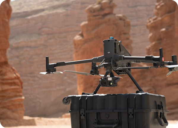
Step into the future of enterprise aerial operations with the DJI Matrice 400.
This is a redefinition of what the DJI flagship drone platform can achieve, offering an intuitive extension of your team’s capabilities. It delivers a performance that pushes beyond its predecessor’s limits, tackling the most demanding tasks—from emergency responses to detailed inspections—with a new level of intelligence and rugged adaptability.
This new generation of the Matrice comes with extended flight time, high-speed performance, a payload capacity of up to 6 kg, power-line-level obstacle sensing, and many other features.

Extended Flight Time, High Speed Performance

6kg Payload Capacity With Versatile Compatibility

Safe and Reliable Flight

Enhanced Intelligence and Efficiency

Easier Automated Operations

Comprehensive Accesory Upgrades
SPECS
The Dock 2 offers several improvements over the previous model, offering improved operations and better than ever results for a docking station.
Takeoff Weight (with propellers):
Without Batteries: 5020±20 g
With Batteries: 9740±40 g
(The actual product weight may vary due to differences in batch materials and external factors.)
Max Takeoff Weight: 15.8 kg
Dimensions: Unfolded: 980×760×480 mm (L×W×H) (with landing gear) / Folded: 490×490×480 mm (L×W×H) (with landing gear and gimbal) (Maximum dimensions excluding propellers.)
Max Payload: 6 kg (The 6 kg payload is measured at the third gimbal connector under sea level conditions. Payload capacity decreases as altitude increases. For details, refer to the official user manual.)
Max Ascent Speed: 10 m/s
Max Descent Speed: 8 m/s
Max Horizontal Speed (at sea level, no wind): 25 m/s
Max Takeoff Altitude: 7000 m
Max Flight Time (no wind): 59 minutes
(Measured with the aircraft flying forward at a constant speed of 10 m/s in a windless environment at sea level, carrying only the H30T (total weight 10,670 g), and from 100% battery level until 0%. Data is for reference only. Actual experience may vary depending on the environment, usage, and firmware version.)
Max Hover Time (no wind): 53 minutes
(Measured with the aircraft hovering in a windless environment at sea level, carrying only the H30T (total weight 10,670 g), and from 100% battery level until 0%. Data is for reference only. Actual usage time may vary depending on the flight mode, accessories, and environment.)
Max Flight Distance (no wind): 49 km
(Measured by the aircraft flying forward at a constant speed of 17 m/s in a windless environment at sea level, without external payloads, and from 100% battery level until 0%. Actual experience may vary depending on the environment, usage, and firmware version.)
Max Wind Speed Resistance: 12 m/s
Operating Temperature: -20° to 50° C (-4° to 122° F) (without solar radiation)
Global Navigation Satellite System (GNSS): GPS + Galileo + BeiDou + GLONASS*
* GLONASS is supported only when the RTK module is enabled.
RTK GNSS Accuracy: RTK Fix: 1 cm + 1 ppm (horizontal), 1.5 cm + 1 ppm (vertical)
RTK Heading: Supports RTK heading with an accuracy better than 2°
Airborne ADS-B In: Equipped with standard airborne ADS-B In receiver and dual antennas, supporting reception up to 20 km.
Internal Storage: N/A
Ports: USB-C Debug Port × 1: USB 2.0 / E-Port V2 × 4: At the lower part of the drone, with 120W single-port power / Cellular Dongle 2 Interface × 2: On the underside of the drone
Ingress Protection Rating: IP55 (The rating is not permanently effective and may decrease due to product wear and tear.)
Maximum Payload for Single Gimbal Connector: 1400 g
(If exceeds, the gimbal damper lifespan will decrease from 1000 hours to 400 hours.)
Maximum Payload for Dual Gimbal Connector: 950 g
Maximum Payload for Third Gimbal Connector: 3 kg for quick-release port, 6 kg for screw lock fastening
Sensing Type: Omnidirectional binocular vision system (surround view provided by full-color fisheye vision sensors) / Horizontal rotating LiDAR, upper LiDAR and downward 3D infrared range sensor / Six-direction mmWave radar
Forward:
Measurement Range: 0.4-21 m
Detection Range: 0.4-200 m
Field of View (FOV): 90° (horizontal), 90° (vertical)
Backward:
Measurement Range: 0.4-21 m
Detection Range: 0.4-200 m
Field of View (FOV): 90° (horizontal), 90° (vertical)
Lateral:
Measurement Range: 0.6-21 m
Detection Range: 0.5-200 m
Field of View (FOV): 90° (horizontal), 90° (vertical)
Downward:
Measurement Range: 0.5-19 m
The FOV to the front and rear is 160° and 105° to the right and left.
Rotating LiDAR
Standard Measurement Range: 0.5-100 m @ 100,000 lux with 10% reflectivity target / Measurement Range for Power Line: 35 m @ 30° @ 10,000 lux for 21.6 mm steel-core aluminum stranded wire with a relative body tilt angle of 30° to the left and right / Field of View (FOV): 360° (horizontal), 58° (vertical) / Point-Frequency: 520,000 points/second / Laser Wavelength: 905 nm / Eye Safety Level: Class 1 (IEC60825-1:2014), eye-safe
Upper LiDAR (3D ToF): 0.5-25 m at night (reflectivity > 10%) / The FOV to the up and down is 60° and 60° to the right and left.
Downward 3D Infrared Range Sensor: Measurement Range: 0.3-8 m (reflectivity > 10%) / The FOV to the front and rear is 60° and 60° to the right and left.
mmWave Radar: Measurement Range for Power Line: 36 m for a 12.5mm steel-core aluminum stranded wire / 50 m for a 21.6mm steel-core aluminum stranded wire / FOV: ± 45° (horizontal and vertical)
The mmWave radar function is unavailable in some countries/regions.
FPV Camera
Resolution: 1080p
Field of View (FOV): DFOV: 150° / HFOV: 139.6° / VFOV: 95.3°
Frame Rate: 30fps
Night Vision: Starlight Grade
Video Transmission
Video Transmission System: DJI O4 Enterprise Enhanced Video Transmission System
Live View Quality: Remote Controller: 3-channel 1080p/30fps
Operating Frequency and Transmitter Power (EIRP): 902-928 MHz: < 30 dBm (FCC), < 16 dBm (MIC) / 1.430-1.444 GHz: < 35 dBm (SRRC) / 2.4000-2.4835 GHz: < 33 dBm (FCC), < 20 dBm (CE/SRRC/MIC) / 5.150-5.250 GHz: < 23 dBm (FCC/CE) / 5.725-5.850 GHz: < 33 dBm (FCC), < 14 dBm (CE), < 30 dBm (SRRC)
Operating frequency allowed varies among countries and regions. Refer to local laws and regulations for more information.
Max Transmission Distance (unobstructed, free of interference): 40 km (FCC) / 20 km (CE/SRRC/MIC)
Measured in an unobstructed environment free of interference. The above data shows the farthest communication range for one-way, non-return flights under each standard. During your flight, please pay attention to RTH reminder on the DJI Pilot 2 app.
Max Transmission Distance (with interference): Strong interference (dense buildings, residential areas, etc.): approx. 1.5-6 km / Medium interference (suburban counties, city parks, etc.): approx. 6-15 km / Weak interference (open spaces, remote areas, etc.): approx. 15-40 km
(Data is tested under FCC standard in unobstructed environments of typical interference. Only to serve as a reference and provides no guarantee as to the actual flight distance.)
Max Download Speed: Standard Mode: 80Mbps Downlink / Playback Download: < 25 MBps / Single-Channel Bitrate: ≤ 12 Mbps
(The above data was measured under conditions where the aircraft and remote controller were in close proximity without interference.)
Antenna: WLAN Antenna × 8: 6 vertically polarized antennas and 2 horizontally polarized antennas / sub2G Antenna × 2: 2 vertically polarized antennas / 4G Antenna × 4
Operating Mode: 2T4R
Others: Supports Dual Control Mode and 2-channel Cellular Dongle 2
Model: TB100
Capacity: 20254 mAh
Standard Voltage: 48.23 V
Max Charging Voltage: 54.6 V
Cell Type: Li-ion 13S
Energy: 977 Wh
Weight: 4720 ± 20 g
Charging Temperature: 5° to 45° C (41° to 113° F)
Discharging Temperature: -20° to 75° C (-4° to 122° F)
Battery Heating: Single Battery: Support / Onboard: Support / Battery Station: Support
Discharge Rate: 4C
Max Charging Power: 2C
Low-Temperature Charging: Supports low-temperature self-heating charging
Cycle Count: 400